

Nowadays it seems almost pointless to understand geographic coordinates, let alone calculate the distance between two points on Earth described by them. Even though there is little practical use to an average person who has just recently stumbled upon Earth's coordinates, it remains to be one of the most important tools used in navigation and long distance travel.
Throughout human history, one of the most important questions has been, 'Where are we?'. As people migrated, the next logical question was, 'Where are you going?'. So it was obviously a good idea to come up with something that would be used to describe one location in reference to the other. Even after the invention of navigational instruments, such as compass and quadrant, most of the exploration was based on landscape features and on celestial navigation. So, it is not surprising that Christopher Columbus accidentally discovered America (for Europeans), even though he was supposed to sail to India by going west to reach the Far East. At his death, he was still convinced that his explorations had been along the east coast of Asia. [Columbus's reaction as he was being explained where India is.] Jokes aside, Columbus was a great explorer.
It was not until mid-18th century, however, that the measurement of geographic coordinates was possible. Surprisingly, latitude has been used since some two thousand years ago but it was fairly useless without longitude which was finally understood in the 18th century. With latitude and longitude known it was finally possible to establish a geographic coordinate system that enabled every location on Earth to be defined by a set of numbers, known as the geographic coordinate.
What is Latitude and Longitude?

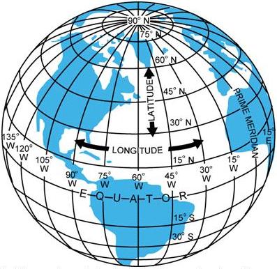
Latitude (not to be confused with altitude) is the distance from the equator. The distance from equator is called 'angular distance' because it is the angle that is being measured. If you draw a line from Earth's core to the surface on equator you will get a base 0° line. Drawing the second line from the core to any location on the surface and measuring the angle between the two lines will give you an latitude angular distance given in degrees (°), minutes (') and seconds ("), followed by the direction in relation to equator - N for North, S for South OR the minus (-) prefix for South . (eg. 45° S = -45°). Since equator is the mid-point from North to South, it doesn't have a direction affix and is commonly known as 0° latitude. Imaginary curves of constant latitude (running east-west) are known as lines of latitude. Each line is parallel to equator, and for this reason they are also known as parallels. Geographic North and South Pole are two points on the Earth's surface that are the farthest from equator. They both have 90° angular distance from equator. (ie. North Pole = 90° N, South Pole = 90° S). Latitude ranges from 0 degrees at equator, to 90 degrees at North Pole (-90 degrees at South Pole).
Longitude, much like latitude, describes an angular distance. Instead of equator, the starting point for longitude is the Prime Meridian - an imaginary line running north-south through Greenwich in London. The reason for this lies in this particular meridian's popularity in late 19th century. Most explorers and overseas traders of that time used the Greenwich Meridian as the reference meridian on their maps, so it was only natural that it was later selected as the official Prime Meridian.
Every location west of Prime Meridian is given an affix W (eg. 110° W), while locations east of it are given E affix (eg. 60° E). The interpretation of East and West is a bit different than that of North and South. That is because the meridians, unlike lines of latitude, are not parallel. They intersect at the poles. If they were parallel, the grid may look somewhat normal on the globe, but as soon as you would try to stretch it into a map, you would notice the chaos.
Since meridians aren't parallel, it is a little harder to pick up the difference between West and East than North and South. Where exactly does East become West? As it turns out the Prime Meridian goes around the World and divides the two. From Greenwich (going north) it crosses the North Pole, Bering Strait (going south), then barely misses New Zealand, crosses the South Pole and makes its way up north over the Western Africa. Most of the land mass is East of Prime Meridian, thanks to Pacific and Atlantic oceans. Longitude ranges from 0 degrees at the Prime Meridian, to 180 degrees in both directions - West and East.
Knowing both latitude and longitude, it is possible to assign coordinates to every place on Earth. For example, New York City has the coordinates: 40°43′N 74°00′W.
Simple Facts, Simple Maths
Since Earth is spherical, every degree of longitude does not represent equal distances. Latitude, however, does. This means that difference of 1 geographic minute (1') in north-south direction is the same everywhere on Earth and is close to 1.8km. The same cannot be said for the difference of 1 minute in longitude. Meridians are not parallel so the length (in km) of 1' in east-west direction varies with latitudinal position - in simple terms, the length (in km) of 1' in east-west direction is different on equator than it is close to the North/South Pole, as it is anywhere in between.
It is quite easy to calculate the distance between two coordinates. All you need to know is Earth's radius (~6400km), coordinates and have basic knowledge of trigonometric functions.
This is not 100% accurate though - I rounded up Earth's Radius and assumed that Earth is a perfect sphere (it's not). Also, the distance between two locations is linear (for easier calculations), not spherical, so if you calculate the distance between North and South Pole, you will get the distance through the Earth's core and not around the globe. Similar can be said for other large distances.
When calculating, it is essential to convert units into degrees only. (eg. 30' = 0.5°).
1° = 60' = 3600"
(1' = 60")
North-South Calculations:
There are two coastal towns in South Korea, Anmyeon-do (36°20'N 126°21'E) and Sapsi-do (36°28.5'N 126°21'E). They are both of almost same longitude (I skipped geo. seconds).
The distance between two coordinates of same longitude is calculated like this:
y = sin ([difference in latitude]) * [Earth's radius] =
= sin (8.5') * 6400km =
= sin (8.5/60) * 6400km =
= (~) 15.8km
The two towns are 15.8km apart.
East-West Calculations:
Two towns/cities in Vietnam, Chợ Ái Nghĩa (15°53'N 108°06'E) and Hội An (15°53'N 108°19.5'E).
The distance between two coordinates of same latitude is calculated like this:
x = |((cos [latitude coordinate]) * 2pi * [Earth's radius]) * [difference in longitude]) / 360 | =
= |(cos (15.9°) * 2 * 3.14 * 6400km * (13.5')) / 360| =
= |(cos (15.9°) * 2 * 3.14 * 6400km * (13.5/60)) / 360| =
= (~) 24.2km
Hội An and Chợ Ái Nghĩa are 24.2km from each other.
East-West & North-South Calculations:
To do this you must separately calculate the north-south and east-west distances. Once you have them, you use the Pythagorean theorem to get the distance between the two coordinates.
x² + y² = a²
a = sqrt(x² + y²), where 'a' is the distance between two coordinates.
Throughout human history, one of the most important questions has been, 'Where are we?'. As people migrated, the next logical question was, 'Where are you going?'. So it was obviously a good idea to come up with something that would be used to describe one location in reference to the other. Even after the invention of navigational instruments, such as compass and quadrant, most of the exploration was based on landscape features and on celestial navigation. So, it is not surprising that Christopher Columbus accidentally discovered America (for Europeans), even though he was supposed to sail to India by going west to reach the Far East. At his death, he was still convinced that his explorations had been along the east coast of Asia. [Columbus's reaction as he was being explained where India is.] Jokes aside, Columbus was a great explorer.
It was not until mid-18th century, however, that the measurement of geographic coordinates was possible. Surprisingly, latitude has been used since some two thousand years ago but it was fairly useless without longitude which was finally understood in the 18th century. With latitude and longitude known it was finally possible to establish a geographic coordinate system that enabled every location on Earth to be defined by a set of numbers, known as the geographic coordinate.
What is Latitude and Longitude?
Latitude (not to be confused with altitude) is the distance from the equator. The distance from equator is called 'angular distance' because it is the angle that is being measured. If you draw a line from Earth's core to the surface on equator you will get a base 0° line. Drawing the second line from the core to any location on the surface and measuring the angle between the two lines will give you an latitude angular distance given in degrees (°), minutes (') and seconds ("), followed by the direction in relation to equator - N for North, S for South OR the minus (-) prefix for South . (eg. 45° S = -45°). Since equator is the mid-point from North to South, it doesn't have a direction affix and is commonly known as 0° latitude. Imaginary curves of constant latitude (running east-west) are known as lines of latitude. Each line is parallel to equator, and for this reason they are also known as parallels. Geographic North and South Pole are two points on the Earth's surface that are the farthest from equator. They both have 90° angular distance from equator. (ie. North Pole = 90° N, South Pole = 90° S). Latitude ranges from 0 degrees at equator, to 90 degrees at North Pole (-90 degrees at South Pole).
Longitude, much like latitude, describes an angular distance. Instead of equator, the starting point for longitude is the Prime Meridian - an imaginary line running north-south through Greenwich in London. The reason for this lies in this particular meridian's popularity in late 19th century. Most explorers and overseas traders of that time used the Greenwich Meridian as the reference meridian on their maps, so it was only natural that it was later selected as the official Prime Meridian.
Every location west of Prime Meridian is given an affix W (eg. 110° W), while locations east of it are given E affix (eg. 60° E). The interpretation of East and West is a bit different than that of North and South. That is because the meridians, unlike lines of latitude, are not parallel. They intersect at the poles. If they were parallel, the grid may look somewhat normal on the globe, but as soon as you would try to stretch it into a map, you would notice the chaos.
Since meridians aren't parallel, it is a little harder to pick up the difference between West and East than North and South. Where exactly does East become West? As it turns out the Prime Meridian goes around the World and divides the two. From Greenwich (going north) it crosses the North Pole, Bering Strait (going south), then barely misses New Zealand, crosses the South Pole and makes its way up north over the Western Africa. Most of the land mass is East of Prime Meridian, thanks to Pacific and Atlantic oceans. Longitude ranges from 0 degrees at the Prime Meridian, to 180 degrees in both directions - West and East.
Knowing both latitude and longitude, it is possible to assign coordinates to every place on Earth. For example, New York City has the coordinates: 40°43′N 74°00′W.
Simple Facts, Simple Maths
Since Earth is spherical, every degree of longitude does not represent equal distances. Latitude, however, does. This means that difference of 1 geographic minute (1') in north-south direction is the same everywhere on Earth and is close to 1.8km. The same cannot be said for the difference of 1 minute in longitude. Meridians are not parallel so the length (in km) of 1' in east-west direction varies with latitudinal position - in simple terms, the length (in km) of 1' in east-west direction is different on equator than it is close to the North/South Pole, as it is anywhere in between.
It is quite easy to calculate the distance between two coordinates. All you need to know is Earth's radius (~6400km), coordinates and have basic knowledge of trigonometric functions.
This is not 100% accurate though - I rounded up Earth's Radius and assumed that Earth is a perfect sphere (it's not). Also, the distance between two locations is linear (for easier calculations), not spherical, so if you calculate the distance between North and South Pole, you will get the distance through the Earth's core and not around the globe. Similar can be said for other large distances.
When calculating, it is essential to convert units into degrees only. (eg. 30' = 0.5°).
1° = 60' = 3600"
(1' = 60")
North-South Calculations:
There are two coastal towns in South Korea, Anmyeon-do (36°20'N 126°21'E) and Sapsi-do (36°28.5'N 126°21'E). They are both of almost same longitude (I skipped geo. seconds).
The distance between two coordinates of same longitude is calculated like this:
y = sin ([difference in latitude]) * [Earth's radius] =
= sin (8.5') * 6400km =
= sin (8.5/60) * 6400km =
= (~) 15.8km
The two towns are 15.8km apart.
East-West Calculations:
Two towns/cities in Vietnam, Chợ Ái Nghĩa (15°53'N 108°06'E) and Hội An (15°53'N 108°19.5'E).
The distance between two coordinates of same latitude is calculated like this:
x = |((cos [latitude coordinate]) * 2pi * [Earth's radius]) * [difference in longitude]) / 360 | =
= |(cos (15.9°) * 2 * 3.14 * 6400km * (13.5')) / 360| =
= |(cos (15.9°) * 2 * 3.14 * 6400km * (13.5/60)) / 360| =
= (~) 24.2km
Hội An and Chợ Ái Nghĩa are 24.2km from each other.
East-West & North-South Calculations:
To do this you must separately calculate the north-south and east-west distances. Once you have them, you use the Pythagorean theorem to get the distance between the two coordinates.
x² + y² = a²
a = sqrt(x² + y²), where 'a' is the distance between two coordinates.
20 insights:
i vaguely remember learning this
Gaaah, making my head hurt
Geography is cool, but I'll skip the maths...
good to know im not the only one who can do this
Awesome information.. might want to put a page jump in the post.
whoa whoa whoa theres math in geography ahhh mr brain is tooo smaallll
I remember learning this on my Geography lessons, was a pain in the ass. :P
I love travel! Geography can be exciting :)
i remember doing things like this is school
stupid gps's made everyone stupid.. good to see boaties are still forced to rely on a compass and a map, gps's dont count legally
Fantastic write up here.
Cool, never learned this at school. Good to know!
This was always one of my shortcoming in school.
Really good post, very interesting blog you have :)
thx
basically is common knowledge but some of it i didn't know
great stuff mmmm
great stff
thanks, but I already knew this hehe :)
I don't remember learning this ever in class. Thanks
Very interesting stuff man. Thanks!
Post a Comment